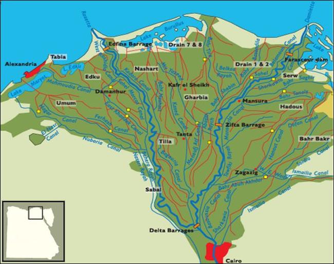
North of Cairo the bordering limestone walls of the valley shrink and diverge from each other, and the river fans out into a number of distributaries. This is the delta of the Nile, a monotonous triangular plain that has been likened to the back of a leaf, for the river and canals stand out like veins above the adjoining lowlands.
Although half the delta is still occupied by lakes and swamps, salt marshes and lagoons, the remainder contains the most fertile soil in Africa. The delta measures about 100 miles from its head to the sea and about 150 along the coast. Its area, 9650 square miles (about 25,000 sq. km.), including the coastal lakes, comprises a little more than three-fourths of the Nile land in Egypt and is nearly equal to the land area of the state of Maryland.
The Delta Land
The delta conforms in outline to a gulf of the Pleistocene Mediterranean and consists of mud that has been laid down since that period by the Blue Nile and the Atbara River. These streams have brought into the mainstream of the Nile the silt from the Ethiopian highlands with which their flood waters are heavily loaded. Although there is some merging of the dark alluvial land of the delta with the light-colored sand of the bordering desert, it is nowhere sufficient to obscure the line of contact between them.
The average thickness of the alluvium is 65 feet, but it varies in depth with the configuration of the sea floor on which it has been laid down. It tends, naturally, to be heaviest and thickest at the south end of the delta and near the two branches that now carry Nile water to the sea. But even in the southern part of the delta an occasional sterile sandy mound, once an offshore island in the ancient Mediterranean gulf, still stands above the alluvium.
North of Cairo, the Nile veers toward the northwest, and about ten miles from the city bifurcates into its two present delta branches — the Damietta (Arabic Dumyat) or eastern branch, and the Rosetta (Rasheed) or western branch. Both are winding streams of considerable width. The Rosetta, 150 miles long, averages 1640 feet wide, and the Damietta, a few miles longer, 885 feet. Of the delta land, 40 per cent is between these branches and 39 and 21 per cent, respectively, east and west of them.
The eastern and western extensions of the delta land correspond to the extent of the Nile flood in ancient times, when not two, as now, but several branches carried the Nile water to the sea. As late as the first century A. D., Strabo reported the Nile as having seven branches, and a twelfth century map by Idrisi, the Arab geographer, shows six branches but indicates a trend toward consolidation into the present two. The most easterly of these, the Pelusaic, to which the early canal makers connected their waterways to the Gulf of Suez, at one time carried water as far east as Pelusium or Tina Bay, east of the present Mediterranean entrance to the Suez Canal.
Owing to the somewhat greater flow until fairly recent times of Nile water and Nile silt across the eastern side of the delta than across the western side, the surface of the delta slopes down slightly from southeast to northwest, but to all appearances it is a remarkably level plain. Its elevation at its apex is only a little more than fifty feet above the sea and its average slope only 1:10,000. A wide belt along the coast, called in Arabic “barari” (barren land), is so close to sea level that only by pumping for drainage and constantly battling against salinity can a large and muchneeded acreage there be reclaimed for cultivation.
A considerable part of this coastal belt is occupied by four shallow, brackish lakes — from east to west, Manzala, Burullus, Idku, and Maryut. These lakes are separated from the sea by only a low sand belt varying in width from narrow bars to stretches several miles across. Besides serving as outlets for most of the drainage from the cultivated land of the delta, these lakes support a fishing industry which supplies most of the fish on sale at the delta markets. Part of the catch is sold fresh in nearby urban centers; the remainder is salted for wider distribution. Matariya (on Lake Manzala). Baltim (on Lake Burullus), and Idku (on Lake Idku) are the principal fishing villages.
Lake Manzala (560 square miles) extends eastward from near the lower Damietta Branch to the Isthmus of Suez, where part of the land on which Port Sa’id stands was built up by filling in some of the eastern end of the lake. Lake Burullus (215 square miles) lies between the two Nile branches, and Lake Idku (55 square miles) faces the curve of Abu Qir Bay west of the Rosetta Branch. The surface of Maryut (76 square miles), south of Alexandria, is a few feet below sea level, but it is barred from the sea by limestone ridges.
The alluvial projections that the Damietta and Rosetta branches have built out at their mouths break the delta coast line into three smooth crescentic curves, of which Abu Qir Bay is the only indentation of any prominence. Cape Abu Qir, which marks its western limit, is the terminus of the limestone ridges that parallel the coast to the west (see section on the Western Desert in this chapter). The sea off the delta front is shallow and its floor gently sloping. Within ten miles of the coast it is nowhere more than 20 meters (65.6 feet) deep, and the 50-meter (164-foot) bathy-metric contour lies at an average distance of twenty-five miles offshore.
Since ancient times, the sinking of the delta’s Pleistocene foundation has kept pace with the deposition of Nile silt. In spite of the enormous quantities of silt deposited there each year (until the present complete perennial irrigation of all the land under cultivation in the delta was well advanced) by the Nile flood, there has been no perceptible increase in the elevation of the delta above the sea. Evidence of the subsidence of the delta foundation is to be seen in the ruins of Graeco-Roman settlements at or below sea level along the coast between Alexandria and Cape Abu Qir and in the remains of still more ancient settlements submerged in the coastal lakes or appearing as islands in the marshlands and lagoons around Lakes Burullus and Manzala.
Since records have been kept, there has been no seaward extension of the delta of any consequence, even though during the height of the Nile flood a large volume of silt-laden water is discharged through the Damietta and Rosetta branches. The west-east Gibraltar current along the African coast of the Mediterranean is so effective in carrying the Nile silt eastward that there is no perceptible accumulation of it except at the mouths of these branches. The bars it forms there are serious obstacles to coastwise vessels entering and leaving the ports of Damietta and Rosetta.
Visits: 458