Vancouver is the leading city of the region. It has a population of 611,869, making it not only the largest city in British Columbia, but third in all of Canada. The metropolitan district embraces 2,249,725 people.
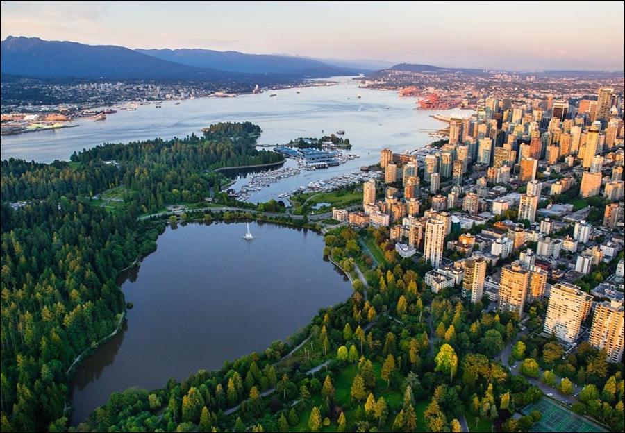
Burrard Inlet, a remarkably deep fiord, provides an ice-free harbour which is the city’s major asset. The city is situated on a rolling upland between it and the flat delta of the Fraser River, to the south. North of the inlet rise the rugged peaks of the Coast Range, providing a very scenic background. Few cities in the world can equal its superb natural setting.
Although its climate is broadly classified as maritime, Vancouver has many microclimates. For example, average annual rainfall varies from 40 inches at the Airport (5 feet), located on the Fraser delta, to 140 inches at Seymour Falls (700 feet), 10 miles to the north on the slopes of the Coast Mountains. Dense radiation fogs which form most frequently during the autumn and early winter are confined almost entirely to low lying areas below 200 feet. Upland districts, such as Shaughnessy Heights, Point Grey and Burnaby Heights, rarely have fog. Gales often blow in the open straits to the west of the city, but the harbour area is well protected from gusts and squally weather.
Historical Factors
Vancouver is a young city. Hastings Saw Mill, built in 1865, was the first permanent settlement on Burrard Inlet. Apart from the saw mill a few small settlements fringed the Inlet, collectively known at various times as “Granville,” “Gastown,” “Liverpool,” “Hastings,” etc. Incorporation occurred in 1886 and Vancouver was chosen as the name of the new town in memory of the first British explorer to visit the area. New Westminster and Victoria had been booming frontier towns for about 25 years but their supremacy was soon lost to the new city. The completion of the Canadian Pacific Railway initiated a rapid growth. The population, in 1886, was approximately 1,000; in 1890, 13,000, in 1910, 100,000.
The building of the Panama Canal lifted Vancouver to the position of a competitor in the Atlantic trade, as well as in the Pacific. Grain was the commodity which stimulated the growth of the city and caused the elevation of its status to that of a great seaport. In 1921, just over one million bushels were shipped from this port but, in 1932, 105 million bushels were exported.
Vancouver tapped the western Prairies and drew the grain away from its customary eastern routes, to the much cheaper western route to Europe via the Panama Canal. Nine large grain elevators on Burrard Inlet reflect the importance of this commodity in the economy of the port. The population increased from 163,000 in 1921 to 246,000 by 1931. Lumber and fish products remained significant exports throughout its history.
Functions
Vancouver is a natural breakpoint between land and sea communications. Being the terminus for two railways and many steamship lines, and with innumerable warehouses and wholesale establishments, the city is, fundamentally, a trade and transportation centre.
Manufacturing is locally important. Sawmilling, sugar refining and miscellaneous food products, petroleum refining, fish processing, metal work and machinery, printing and publishing were leading industries. Under wartime conditions shipbuliding was of major importance.
The educational function of Vancouver is represented by the University of British Golumbia, which is situated in the extreme western part of the city, overlooking the sea.
Urban Landscapes
The most important section of the city is the port area adjoining Burrard Inlet. Intermingled with large docks, elevators and storage plants are many industries. Another industrial zone is found in the False Creek Lowland where saw mills predominate. The commercial core, including retail and wholesale districts, is situated on a rise of land between False Creek and Burrard Inlet. The Chinese Quarter, second in size to San Francisco’s in North America, is a colourful section on the eastern edge of the commercial zone.
The residential city has spread from its first settlement along Burrard Inlet, southward until it covers most of the upland area between the harbour and the Fraser River. Shaughnessy Heights, Drummond Drive, and the University Heights are first class districts. Shaughnessy, set aside by the Canadian Pacific Railway Company for residential purposes, is the most extensive and modern area. The other two have unparalleled views of the Inlet and the Coast Mountains. The “West End”, adjacent to Stanley Park, is a separate district of old, large, houses built a half century ago. Many are now used as boarding houses or apartments.
Second class residential districts such as Dunbar, Kitsilano, Kerrisdale, Point Grey, Fairview and South Vancouver, have neat, well-kept and well-spaced houses. Flower gardens decorate all homes from the largest mansion to the most humble dwelling. Crowded houses, so common in the east, are rarely seen. Slums are restricted to a few areas in the downtown district and the east end. A diversified area, made up of scattered farms, Chinese truck gardens, a few houses, golf courses and some industrial development, appears in the southeastern and southwestern parts of the city.
Suburban Areas
Several smaller communities, whose life is very closely tied in with Vancouver, are situated to the north, east and south of the city proper. North Vancouver is an industrial and residential suburb on the north shore of Burrard Inlet, at the foot of the towering Coast Mountains. Shipbuilding and saw milling are the main manufacturing industries. West Vancouver is spread out along Burrard Inlet to the west of North Vancouver. It is a residential suburb with many beautiful houses, including those in British Pacific Properties–a well-developed subdivision on the south-facing slope of Hollyburn Mountain.
Burnaby is a large municipality located just east of Vancouver. It is a residential suburb which has not as yet been incorporated into the city. Port Moody is a small community situated at the head of Burrard Inlet, about 12 miles east of Vancouver. It was selected as the terminus of the Canadian Pacific Railway in 1884, but was later abandoned in favour of Vancouver. The town has a few saw mills, and oil refineries are found at Ioco across the Inlet.
Related Link: Travel to Canada
Visits: 68