Toronto is the capital and largest city in Ontario. Located on the north shore of Lake Ontario, it is 43 miles from Hamilton, 340 miles west from Montreal, 228 miles east from Windsor and 222 miles south of North Bay. It is thus very centrally located in Southern Ontario and is the focus from which radiate both railways and provincial highways.
From the Malton airport it has direct airline service, while in its harbour may be found large steamships from all parts of the Great Lakes, and smaller ones from all parts of the world. The population of the city as 2,503,281, and of the “greater city” as 5,555,912. Included in the metropolitan area are the towns of Leaside, Mimico, New Toronto, and Weston; the villages of Forest Hill, Swansea, and Long Branch; and the townships of York, North York, East York, Scarborough, and Etobicoke. Toronto is the political, commercial, industrial, financial, educational and cultural centre of the whole province.
History
Toronto is a name of Indian origin, signifying “place of meeting”. The vicinity was frequented by the Huron Indians and was the start of an overland route to Lake Simcoe and Georgian Bay. In 1615, the site was visited by Samuel de Champlain and Etienne Brûlé. A French fort was established in 1720 and abandoned ten years later. Again in 1749, Fort Rouille was built near the Humber River but was evacuated in 1759. In 1793, Governor Simcoe selected the shore of Toronto Bay as the site of the settlement of York which soon became the capital of Upper Canada. It was burned by American invaders in 1813, but was rebuilt.
It was incorporated as a town in 1817, and as a city with a population of 9,254 in 1834. Its name was changed back to the original Toronto, although York was the name retained for the surrounding township and the county of which it was the judicial seat. Although eventually losing the race for capital of all Canada, it has remained the capital of its most populous province as well as its commercial metropolis. Consequently, the population of Toronto has grown tremendously, causing the city to expand its boundaries a number of times to take in new suburbs. No new annexations have taken place since 1914. Little more than half the population of “Greater Toronto” live within the city proper and the date of further amalgamation may not be far distant.
The Harbour
The site of Toronto was determined by the presence of the harbour which is a small bay, about three square miles in area, shut in by a sandy hook which has been built from materials washed to the west from Scarborough Bluffs. Although it now has two entrances, it originally opened only to the west. Although its shores were shallow, there was a channel 2 1/2 fathoms deep in the entrance and from 3 to 4 fathoms of water in the anchorage in the middle of the bay, making it the best harbour on the lake and one of the easiest to defend.
Over the years the harbour has been greatly changed. In 1853 and again in 1858 great storms broke through the bar, forming the eastern passage. Both it and the western gap have been provided with concrete retaining walls. The bay has been dredged and the shallow shores filled in and two and one-half miles of improved concrete piers erected. The filled-in land now accommodates great railway yards, shipyards, elevators, coal docks and miscellaneous industries. The island, which is reached by ferries, is a great summer resort with parks, cottages, hotels and, beside the Western Gap, a modern airport which, during World War II, was used for the training of Norwegian airmen.
The Site
The site of the early city of Toronto, bordering the northern shore of Toronto Bay, lay entirely within the old bed of Lake Iroquois. The old lake plain, largely Floored with sandy deposits, is about three miles in width and slopes gently northward at a rate of 50 to 60 feet per mile.
Along its northern border are evidences of the old beach and a steep bluff about 75 feet in height representing the old shore cliff. Beyond this is an undulating till plain whose gently rounded summits reach 600 feet above sea level, or more than 350 feet above Lake Ontario. The Doll River, which enters the head of Toronto Harbour, has cut a deep, but flat floored, valley through the eastern part of the city site. Its steep sides and those of the deep narrow tributary ravines have been great natural obstacles to the growth of the city.
Beyond the Don, lies a triangular plain of sandy deposits cut off to the east by Scarborough Bluffs and somewhat dissected along its southern edge by narrow ravines. This plain was built by Lake Iroquois in the same manner as Toronto Island is being built by Lake Ontario. To the west the plain is cut by the Humber Valley and by the steep ravines in High Park and Swansea. Here also the old lake built a huge sandbar shutting off the Humber Valley so that, in the time of Lake Iroquois, there were two Toronto Harbours instead of one.
The site has furnished not only building room but much of the material of which the city was built. The old bars have furnished countless tons of sand and gravel, while in the ravines were exposed deposits of clay suitable for brickmaking.
The Growth of the City
The geographical phenomenon of city growth can best be understood as a series of changes in the pattern of land utilization. They are the results of the pressure of economic and social or human factors upon the physical factors of the site. These at first are simple and Toronto had a very simple beginning. The village of York in 1793 consisted of a rectangular pattern of streets covering about 100 acres near the head of the harbour and consisting of about a dozen blocks in all. Here as time went on were constructed barracks, storehouses, residences, a school, a church and parliament buildings. Growth was slow but eventually a new town was laid out west of Yonge Street.
Here new barracks, parliament building and government house were built. In 1817 these areas were incorporated as the town. Having nearly reached 10,000 in 1834, a city was incorporated. The limits of the corporation were set far beyond the built up city and included about 8 square miles. This had not filled up by 1850, but the coming of the railways in the following decade was the cause of rapid expansion and soon the edge of the city was fringed with suburban villages.
Beginning in 1883 and continuing until 1914, there was a series of annexations which brought the city to its present area of 34 square miles. Until after 1900 the city remained below “the hill”, on the old lake plain. To the east only a small strip along the waterfront and Riverside, along the Don, had been incorporated. To the west Parkdale, Brockton, High Park and the lakeshore as far as the Humber River also came in.
Bloor and Danforth were joined by bridges over the Don and Rosedale ravines in 1914. The double barrier of the old shore cliff and the C.P.R. just below were conquered by dugways and underpasses, and the various districts along St. Clair Avenue were incorporated. Along Yonge Street the city extends for three miles further north than anywhere else, taking in the old villages of Deer Park, Davisville, Eglinton and Bedford Park, all of which had previously been incorporated as North Toronto. Immediately adjoining North Toronto on the east is the town of Leaside, incorporated in 1913, while to the west is the village of Forest Hill which received its charter in 1923. Swansea, lying between the Humber and High Park, became a village in 1925.
Except in the Don valley, however, the built up city extends far beyond all these urban municipality boundaries, including at least 100 square miles. Over it all, with few exceptions, real estate subdividers have enforced the rectangular street pattern, regardless of the grain of the country. Moreover, the railways, taking the easiest grades to reach the water front, have added to the confusion of the pattern. Toronto, throughout, has emulated the celebrated Topsy who “just growed”. Thus there are many gaps, many streets have dead ends against bluffs or ravines, and there are comparatively few through streets.
The Pattern of the Urban Landscape
Despite the grid street pattern, Toronto displays a radial arrangement of its functional zones, albeit badly deranged. The waterfront and the railway facilities, which sought it in the early days, have attracted the chief wholesale and warehouse establishments. The new harbour area, created since 1911, has become the site of many industries.
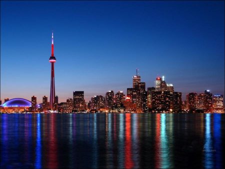
Immediately north of this, with Bay and Yonge Streets as its main arteries, is downtown Toronto. The concentration of business within this area has caused the erection of many tall office buildings. The Bank of Commerce Building is the tallest in the British Empire; the Royal York is the largest hotel. All this can be seen to advantage from Toronto Island, across the harbour, for the buildings of the waterfront are comparatively low structures. Certainly no such massing of humanity was contemplated when the streets were laid out in 1817.
Around this core area, and being gradually displaced by it, is the fourth class area, old and crowded. North of this, centred about the University and Queen’s Park, is the old area of better residences, now the roominghouse district. Stretching away to the east and to the northwest are the massed rows of brick houses built between 1880 and 1910. Most of Toronto’s streets were provided with fine rows of trees, but every year more streets are widened for use as thoroughfares and the trees are sacrificed.
The more expensive houses are found some distance from the city centre or in areas dissected by the old ravines. Rosedale along the ravines just north of Bloor Street is the oldest of these. Others are Forest Hill and Lawrence Park in the north, High Park and the Kingsway in the west, to mention just a few. Beyond the city, at the present time, great areas of small homes are being built.
Toronto housing statistics are interesting. Brick is the most common material and has been used for 83% of all exteriors, second choice is stucco with 8%; 37% are single houses, 30% are semi-detached, while 25% are flats or apartments and 8% are in rows or terraces. 60% of all dwellings have 5 to 8 rooms and 94% have central heating with hot air, steam or hot water. Downtown is the centre of Toronto’s retail business; here one finds the specialty shops and the great department stores.
Along each main street stretch local shopping districts which supply their neighborhoods with most of their daily wants. One might mention Queen Street, Dundas Street, College Street, Bloor Street, Danforth Avenue, St. Clair Avenue and Eglinton Avenue, all prominent east-west thoroughfares, and Yonge Street which is almost a continuous shopping district for seven miles from north to south.
Beside the river valleys and ravines, already mentioned, the chief disturbing elements in the city pattern are the railways for, not only have they attracted many industrial plants, but they have caused many bottlenecks in street transportation, which it has taken a long time to overcome. In fact, so far as north-south transit is concerned, the problem is not yet solved. The modern tendency, however, is to establish new manufacturing plants outside the city. The war plants at Ajax, Scarborough, Leaside, Downsview, Malton and Long Branch are cases in point.
Space in many of these plants has been converted to peace-time industry, while other new industrial buildings are being erected. An interesting case is the creation of the huge new oil refinery at Clarkson together with modern port facilities, sixteen miles away from the old site in Toronto Harbour. Outlying plants mean the creation of outlying residential suburbs. Many wartime houses were built, as at Ajax and Malton, but the village at Clarkson is of more permanent construction. In the outskirts of the metropolitan area, also, are found airports, golf courses, rifle ranges and many private estates of wealthy persons.
Parks
Toronto has a number of fine parks within the city limits. High Park in the west end contains 406 acres, maintained as nearly as possible in a natural state. Riverdale Park, 109 acres lying in the Don Valley, contains the city zoo. Queen’s Park, about 40 acres surrounding the buildings of the Ontario Legislature, is leased by the city from the University.
Exhibition Park, in the southwestern part of the city, comprises 235 acres. It contains the buildings in which are held the Canadian National Exhibition each August and September and the Royal Winter Fair each November. During World War II, many thousands of Canadians passed through the military depots located there. There are many smaller parks in all parts of the city which serve as athletic and recreational grounds. Some of these, such as Christie Park and Eglinton Park, are located in enlarged ravines which for many years were used as brickyards. The total area of Toronto’s park system is over 2,300 acres.
Views: 187


